What is FME?
The only all-data, any-AI platform
TRAINING
Hands-on, practical training for individuals and teams
INTEGRATION
Remove silos, connect all your data and make it usable
CUSTOMER SUCCESS STORY
By creating a self-service workspace application, Auckland Council’s GIS team enabled the Contamination Team to generate their own secure reports in minutes, eliminating manual data handling and freeing analysts for high-value work.


– Nick Webber, Senior Geospatial Analyst,
Auckland Council
The Contamination Team at Auckland Council plays a critical role in managing sensitive site contamination information, from soil disturbance and subdivision to the removal of fuel storage tanks. Each year they handle around 3,000 internal requests and 600 public queries, with about 50 requiring formal Site Contamination Enquiry Reports.
Until recently, every one of those formal requests relied on GIS team intervention to extract and prepare data scattered across 20 separate GIS feature classes. In one major dataset alone, there were 4.8 million records but only 33,000 relevant to contamination work. This meant hours of repetitive handling, added risk of human error and turnaround times stretching from what should have been minutes to as long as three days. The process hadn’t been reviewed in several years, included redundant steps and was diverting GIS analysts from higher-value work.
That began to change when Senior Geospatial Specialist Nick Webber and the GIS team set out to create a faster, simpler and more secure process. Their goal; enable the Contamination Team to generate their own reports without relying on GIS staff, while improving data governance and ensuring the results matched what users saw in Council’s GeoMaps platform.
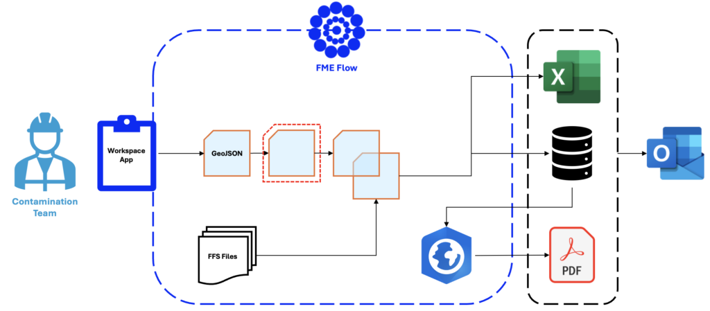
The answer was a self-service Workspace App powered by FME Flow. Accessible entirely through a web browser, it allows non-GIS users to submit spatial queries as points, lines, or polygons using the flexible GeoJSON format. From there, the request runs through an automated workflow to produce a contamination report. Absolutely no downloads, no specialist software and no handovers required.
Behind the scenes, the GIS team re-engineered the data pipeline. Instead of connecting directly to Spatial Database Engine (SDE) systems, which risked slow speeds or timeouts, they now read from optimised FFS files, FME’s native format, generated nightly from master datasets. These files are stripped down to include only the relevant records for contamination reporting and are spatially indexed for speed. The nightly process already supports two automation workflows and is built to scale further.
Equally important was building trust into the process. The GIS team worked closely with Auckland Council’s Data Governance group to identify and remove any fields containing potential personal identifiable information (PII). By engaging with the Contamination Team during development, they also ensured the outputs mirrored GeoMaps results, eliminating the need for extra manual checks.
A request that once took 25 minutes of GIS effort and up to three days to deliver now completes in under two minutes and without GIS involvement.
Since going live, more than 200 reports have been generated, saving an estimated 250 GIS hours each year. Initially deployed for formal Site Contamination Enquiry Reports only, the Contamination team now also use the tool to respond to internal and public contamination queries.
What began as a contamination-focused project is already proving its potential as a model for other council workflows, delivering the speed, accessibility and governance that can make a real difference across the organisation.
By utilizing FME Flow to deliver self-service applications, local authorities can successfully eliminate operational bottlenecks, protect data governance, and empower non-technical staff to access critical insights on demand, maximizing efficiency for both the organization and ratepayers.
Powered by Locus Expertise
Auckland Council’s Contamination Team now saves 250 hours a year using a self-service Workspace App powered by FME Flow, delivering instant contamination reports without GIS involvement.