What is FME?
The only all-data, any-AI platform
TRAINING
Hands-on, practical training for individuals and teams
INTEGRATION
Remove silos, connect all your data and make it usable
CUSTOMER SUCCESS STORY
By combining ArcGIS Online and FME, Hurunui District Council has created an automated, self-service data pipeline that enables its project team to seamlessly push monthly project, progress, and budget updates directly to a public interactive map.


– Dan Harris, Chief Operations Officer, Hurunui District Council

The Hurunui District Council is a local government authority that serves the Hurunui District in New Zealand, a largely rural region located on the east coast of the South Island. The resident base for the council is less than 13,000 people yet the district is the seventh largest territorial authority in New Zealand by land area. Tasked with providing governance and essential services to the residents and businesses within the district, the council is responsible for implementing policies that promote the wellbeing and sustainable development of the community.
The Hurunui District Council set out to create an interactive map for their Long Term Plan projects, aiming for user-friendly design that offers transparency. The map not only engages the public but also provides visibility into project scope, progress, and budget details as it relates to property, public services, roads, water supply and more.
In building the map, the goal was to ensure a positive customer experience for the community and a simple and sustainable solution for monthly updates by project staff, recognizing the challenges of being a small organization.
The partnership between ArcGIS Online and FME has resulted in a comprehensive interactive map solution with various components. This includes a hosted feature layer on the ArcGIS Online platform, which serves as a central repository for all projects. Through a smart editor, the project team can create and edit project geometries and identifiers that are ready to receive monthly data updates. Additionally, information accessibility has been improved by filtering projects based on their status, leading to two public views: current projects and completed projects.
The deployment of FME Workbench ensures streamlined and accurate monthly updates of project information, maintaining data quality and consistency. The introduction of an intuitive Gallery app with a user-friendly interface and an optional backup restore feature delivers easy self-service data updates while preserving data integrity. The successful integration of FME Workbench forms and server flows has created an effortless workflow that supports the efficient management and updating of project information on a regular basis.
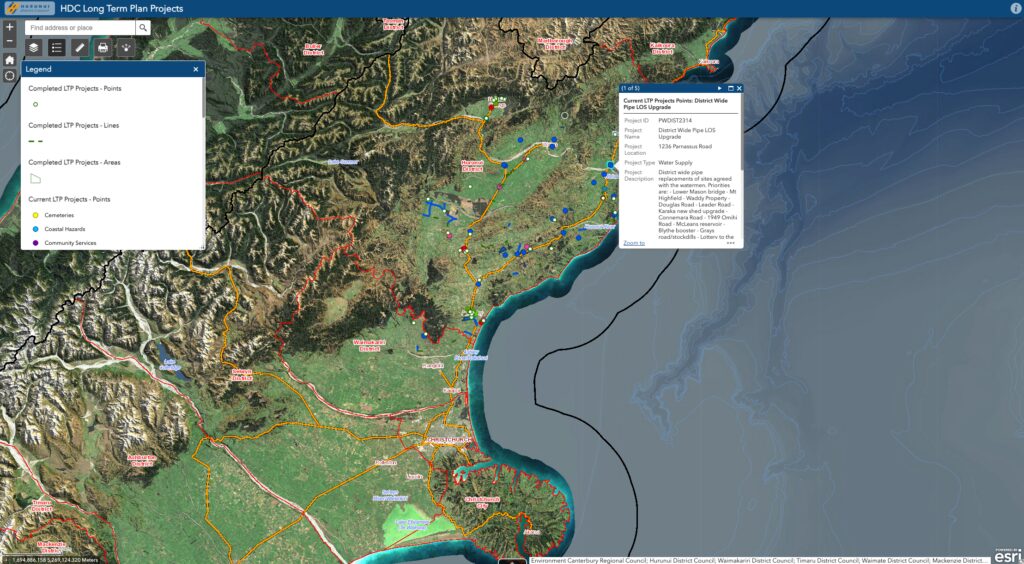
The interactive map is a valuable resource for the Hurunui District community, fostering transparency and engagement. It allows the largely rural community to stay informed about ongoing and completed projects as they relate to Council assets, infrastructure and services including roading, water supply, property, green spaces, recycling services, coastal hazards and more.
Eliciting positive feedback and hundreds of views since being launched in April 2023, the map has quickly established itself as a reliable resource of real-time information.
The Hurunui District Council leveraged FME to bring its vision of an interactive map to life, ensuring the community stays informed about project scopes, progress, and budget allocations.
By utilizing FME to orchestrate regional database updates and automate cloud-mapping flows, local government bodies can remove administrative overhead and bridge the communication gap with their constituents. Automating these updates ensures that public portals display accurate data dynamically, transforming complex capital works spreadsheets into a clear, visual record that builds public trust and simplifies reporting for smaller operational teams.
Powered by Locus Expertise
The Hurunui District Council successfully implemented an interactive map, developed in collaboration with ArcGIS Online and FME, to enhance transparency and community engagement in their Long Term Plan projects, providing a user-friendly interface for tracking project scope, progress, and budget details, with streamlined monthly updates delivering a reliable real-time resource for the community.