Imagine the daunting task of manually creating countless PDF maps, each requiring careful adjustments for location, extent, symbology and labelling.
This repetitive and time-intensive process can quickly become a bottleneck in any GIS workflow. However, with the help of FME and Python, automation can transform a process that historically could take hours and lowering the number of map requests for similar mapping tasks, freeing up time.
Understanding the Process
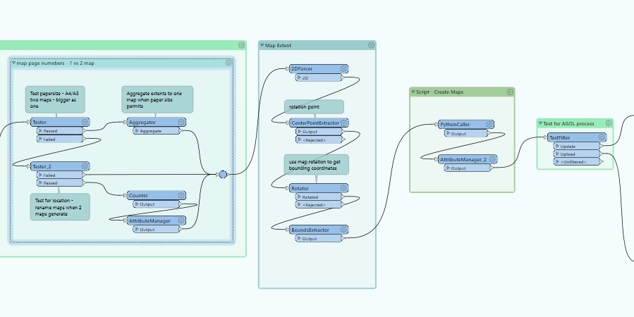
Before diving into the automation, let’s break down the FME Form process. We started with a collection of locations to be mapped with various datasets represented and a set of ArcPro layout templates for different paper sizes. Our goal was to automatically generate the PDF maps for each location at various paper sizes, while customising the map and layout elements for the different scale maps.
FME played a crucial role in this process. By analysing the map locations, FME extracted the boundaries of each map area and determined their orientation and bounding coordinates. This information was then used to set the map extents and select the required ArcPro layout, showing only the features that fell within the respective map extents.
Once the features were identified, Python came into play. Using ArcPy , I created custom scripts to generate the actual maps. The scripts dynamically selected the map areas with the selected features, applying appropriate symbology and labels based on predefined rules. While updated layout elements for each location such as the title and rounding the scale. The completed maps were then exported as PDF files, ready for distribution.
Visualising the Workflow
By automating the map generation process, we’ve significantly improved efficiency. The automation eliminates the need for multiple requests for similar maps and reduces the need for regular manual updates as our data changes over time.

More Resources
Contact Pip NorrisLearn more about FME
Register for FME Accelerator: free 90 min intro to FME


