

ArcGIS Online is a great tool for hosting your data online, and building web maps or apps which you can use to share data with your users. Using FME, you can make sure you’re getting the most from your ArcGIS Online subscription by building some really great workflows to keep your data up to date, pull data down into your organisation, or even administer your ArcGIS Online account.
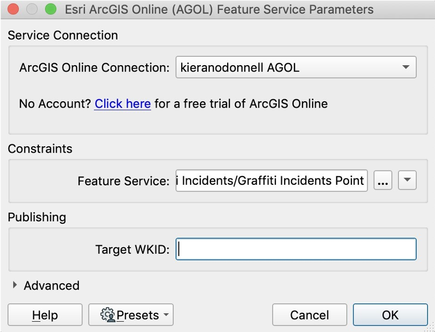
ArcGIS Online Feature Service Writer
The ArcGIS Online Feature Writer is one of many ways you can use FME to integrate with ArcGIS Online. Using this writer, you can create, update or remove data which is in your ArcGIS Online organization. For many organisations publishing datasets to ArcGIS Online creates a bit of a data management headache, as Hosted Feature Services are duplicates of data which is maintained internally.
Using FME however, you can create a simple process to read from your internally maintained dataset, and write directly to the feature service. By running this process on a regular basis, the data hosted in ArcGIS Online will stay up to date and you can have confidence in all your data without a burdensome process to maintain.
ArcGIS Online Feature Service Reader
Using the ArcGIS Online Reader, you can also access any Hosted Feature Service you have published. By adding this into an FME Workspace, you can read the data like any other format. This is particularly useful if you have projects utilising ESRI’s Collector application, and FME even allows you to download the attachments stored against each feature.
Just like using the Feature Service Writer, you can keep two datasets in-sync without needing to constantly process the data yourself. In this case, the master dataset is held in the ArcGIS Online Feature Service, and an internal dataset is the replica which you use to display in your in-house GIS systems.
ArcGIS REST API
Another way to integrate FME with ArcGIS Online is using the REST API. This is slightly more advanced, so users who are unfamiliar with accessing APIs in FME should check out our FME and the art of the API blog article. We’ve also put together a sample workspace you can use to get started. Some instructions are included in the workspace to set this up to work with your own ArcGIS Online account.
The ArcGIS REST API has a wealth of functions you can use to perform geospatial, mapping and administrative functions using your ArcGIS Enterprise organisation or ArcGIS Server. Using FME, you can make HTTP Calls to the ArcGIS REST API to perform these functions in an automated fashion.
In the sample workspace, the process takes you through a fairly simple workflow to perform a query on your ArcGIS Online organisational account. Like most APIs you need to authenticate with ArcGIS Online first to fetch a token, in order to validate you have permissions to perform this function.
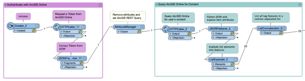
Next, the workspace performs another request to the REST API, querying the portal with the user parameter you have set. This could be for content owned by a specific user, containing a certain tag, or a combination of criteria – the potential is endless. After making the request, the JSON is unpacked and split into individual records. In this case, the output is written to a spreadsheet of items which do or don’t contain tags, but again you can perform any function you wish. Querying the organisation is a great way to keep on top of data or items hosted in ArcGSI Online, in order to ensure duplicates aren’t kept and metadata standards are adhered to over time.
The functions aren’t just limited to querying the portal though. You can use FME to publish services, create new items, or migrate content from one user account to another. If you’re willing to spend a little time developing these processes, you can get some great functionality which will save you plenty of time and effort in administering your organisational account, and ensure it’s always kept up to date. More information on the ArcGIS REST API.
Article Author: Kieran O’Donnell, FME Data Solutions, Locus