Oxfam is a world-wide development organisation that mobilises the power of people against poverty.
The Background
Oxfam New Zealand (Oxfam) works in the Pacific and Southeast Asia working with communities to tackle the root causes of poverty. Oxfam helps people to access safe water and sanitation, to build a sustainable livelihood, to provide education for their children and to live free from persecution and violence.
The Oxfam Trailwalker is the primary fundraising event for Oxfam to meet its objectives with a target of raising NZD$1 million per annum. Originally set up by the legendary elite Queen’s Gurkha Signals Regiment in 1981 as a military exercise to test teamwork, endurance and determination. Participants now tackle 100km in 36 hours, or 50km in 18 hours, through the beauty of the Bay of Plenty alongside their team of 4 and raise funds to fight poverty.
The Challenge
Oxfam Trailwalker is the ultimate team challenge. Physically and mentally demanding, 300+ teams of 4 complete a gruelling 50km or 100km walk all in the name of fundraising. Supporters pledge their financial aid and every year the New Zealand Oxfam Trailwalker event raises up to $1mil to help bring about positive change in people’s lives.
Every Oxfam Trailwalker team must commit to raising at least $2,500 to support Oxfam New Zealand’s work in the Pacific and around the world. A Trailwalker team’s web page is the primary vehicle for recording and broadcasting fundraising progress. Moreover, every team page features a team map that is instrumental in recording team progress through the course, stimulating donations, and providing a much needed safety net for team progression and well-being over the 100km course. Driven by FME and delivered by Locus, all participating teams adopt a map and its associated functionality and share this with its supporter and donators database. Fundraising endeavours are incentivised with rewards provided by event sponsors and teams can upgrade their fundraising commitment on their team page at any time to strive for a greater fundraising target.
The Results
Utilising FME, Locus delivered 300 highly functional Oxfam Trailwalker team maps, the purpose of which is to monitor team progress over the course of the event, promote supporter engagement and fundraising participation and make provision for a very visible mechanism by which team safety and well-being can be observed – all without the requirement for complex or expensive tracking equipment – a little bit of FME can go a long way!
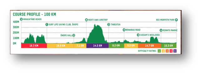
Locus prepared Elevation profiles, created kilometre markers for the trail, enabled team tracking via Twitter and built a race officials dashboard to ensure no team was lost.
Map functionality is delivered by Locus without the requirement for expensive or complex tracking equipment and leverages the use of core FME componentry, including built-in Twitter search and regular expression transformers, to expose latitude and longitude attributes and highlight distance markers and associated tweets.
This FME and Twitter collaboration supports 300+ teams, of 4 people per team, tweeting every kilometre delivering much needed team and supporter engagement which in turns raises the profile of the event and attracts greater $$ support.
The Future
In providing its expertise, Locus collaborates with the Oxfam Events team, Whatakate District Council and Wireless Nation. Locus provides its services free of charge, cherishes the longstanding relationship it holds with Oxfam and looks forward to supporting this event for many more years.

